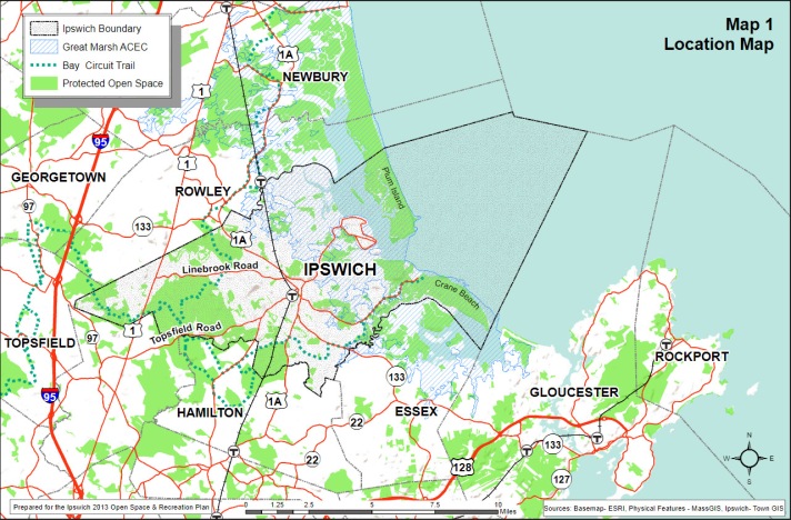
In the year 2000, the town of Ipswich produced a study called the “Green Ring Report” that documented goals for preserving the nature of the outlying areas of the town. Town meetings in Ipswich have voted to protect hundreds of acres of land, making it available for the general public and preserving the land from development. More than 50% of land in Ipswich is protected by the town, state, and non-profit organizations. The town’s investment adds to other preserved land in the town preserved by Willowdale State Forest, Essex County Greenbelt, the Trustees of Reservations, the Ipswich Great Estates Bylaw, and existing municipal facilities and conservation land.

Ipswich Open Space Program
The Open Space Program prepares an annual operating budget that is funded through the Open Space Recreation and Water Supply Protection fund, an off-budget revolving account established in 1999 at Special Town Meeting Article 20 and approved by the Massachusetts Legislature in 2000 under Chapter 366 of the Acts of 2000. The annual budget supports staffing of the Open Space program and expenses related to pre and post-acquisition and stewardship-related open space costs. The revenue sources for the fund include hotel/motel excise tax, roll-back taxes from Chapter 61A (conversion of agricultural property under Chapter 61A to residential property), and income from a cell tower lease on town property.
- Contact: Michelle Vaillancourt, Open Space Program Manager, Town of Ipswich. ph: 978-356-6607 x4; email: michellev@ipswich-ma.gov
- Open Space staff
- Open Space Land Acquisition Policy
- Open Space Bond Parcel List
- Open Space Bond completed projects (PDF)
- Open Space Facility Inventory
- 2013 Open Space and Recreation Plan for the Town of Ipswich
- Town of Ipswich Open Space Program
- Open Space, Recreation, and Water Supply Protection Fund
- 2000 Annual Town meeting $10 million Open Space Bond
- 2011 Annual Town Meeting $5 million Bond Authorization
- History of the Open Space Program
- Open Space Committee
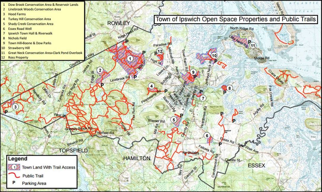
- Open Space trail map
- Town Owned Lands, trails and public properties
- OSRP 2013 – Appendix G – athletic fields report (PDF)
- OSRP 2010 Update – Revised Goals (PDF)
Nichols Field (Town conservation land)

Nichols Field is located at 60 Labor in Vain Road, a 15-acre parcel of open fields and woods adjacent to the Ipswich River, with mowed trails, salt marsh, and river views. Robert Weatherall was among a core group that saved the 14.8 acres of Nichols Field, donating some of their land to expand the original Nichols conservation area, with assistance from Essex County Greenbelt, and a $400,000 purchase by the Town of Ipswich. Shortly after the successful Nichols preservation, Town Meeting passed the open space bond program, leading to other conservation purchases in cooperation with the Essex County Green Belt and the state. Read: Nichols Field Management Plan
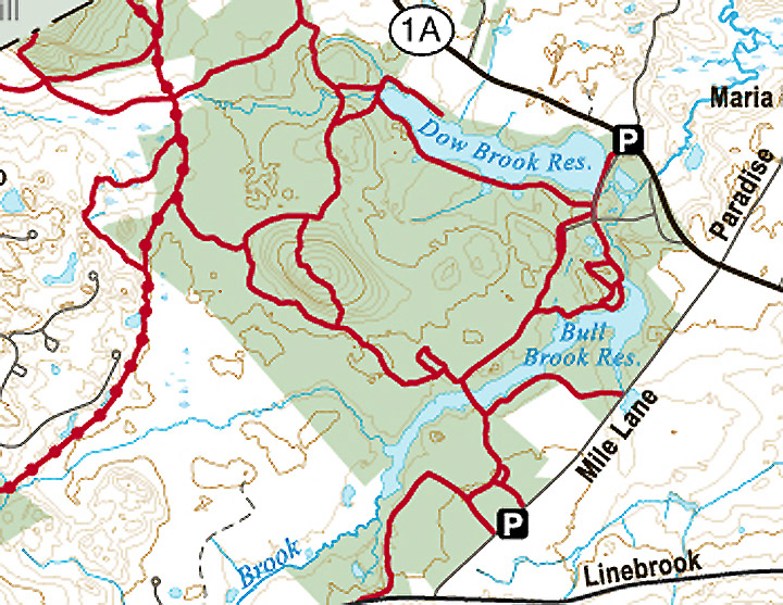
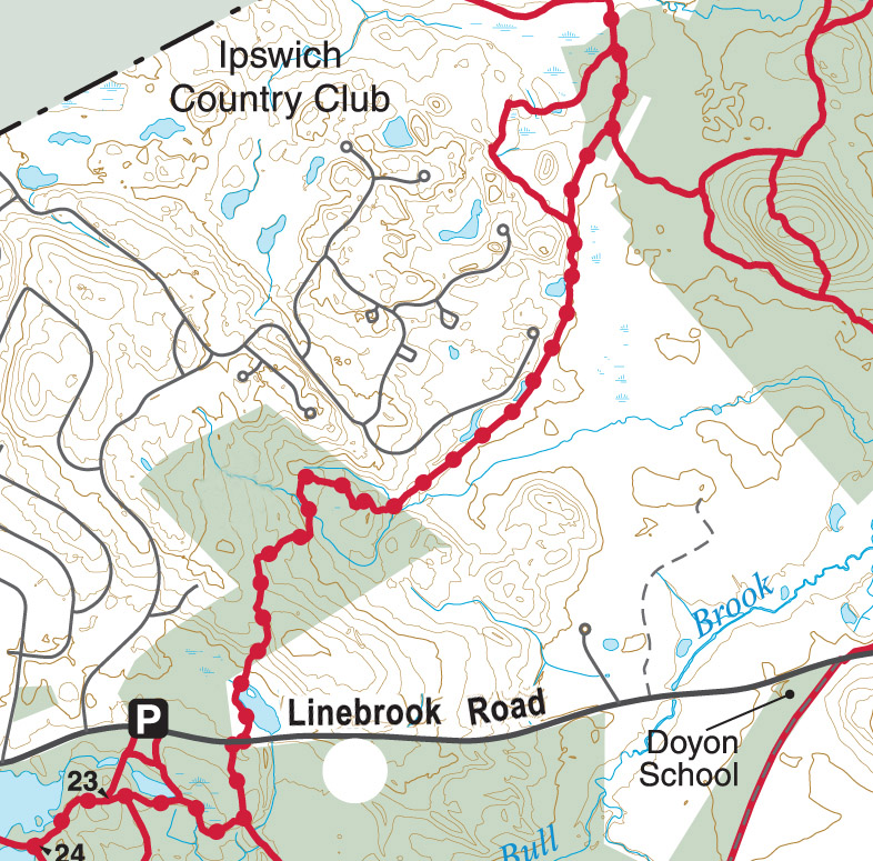
Dow/Bull Brook Reservoirs

Dow Brook Conservation Area (formerly A.C. Builders) – 34 acres – Map 12, LOT 3A – High Street: This parcel has over 800’ of frontage on Dow Brook, which drains directly into the Dow Brook Reservoir, a public drinking water supply, only 650’ from the property line. In addition to providing quality wildlife habitat within a regional greenway of over 3,000 acres, this parcel also provides a key link in the Bay Circuit Trail and numerous opportunities for passive recreation. After reimbursement from the Self‐Help Grant, the Town’s cost for this property was approximately $150,000. Public access to the property is located in a parking area next to White Farms Ice Cream on High Street, near the Rowley town line. Read the Dow Brook Conservation Area Management Plan.

Negotiations for the Town’s acquisition of this parcel began in the spring of 2002 and concluded with the Town’s purchase of the property in April 2003 with assistance from a Self‐Help grant from the Massachusetts Executive Office of Environmental Affairs – Division of Conservation Services for approximately $200,000.
Gaspar Parcel – 22.1 acres – Map 20C, Lot 3 – off of High Street
This undeveloped, landlocked parcel located off of High Street is located less than 100’ from the Dow Brook Reservoir, a main source of drinking water for the Town of Ipswich. It is completely surrounded by town‐owned land in an area that is managed for watershed protection and protection of the Town’s drinking water supply. The owners of this parcel agreed to sell the parcel to the Town for its assessed value of $33,000.
Lynch Property – 1 9 Acres – Map 29C, Lot 3 and 4A, 215 Linebrook Road, 9 Acres – Map 29C, Lot 3 and 4A, 215 Linebrook Road
On June 25, 2008, the Town purchased the Lynch Property on Linebrook Road for the primary purpose of drinking water supply protection for the Bull Brook Reservoir. The property was acquired at a cost of $975,000, of which $495,175 was derived from a Massachusetts Department of Environmental Protection Drinking Water Supply Protection Grant. The remainder of the project cost was covered by the Town’s Open Space Bond Authorization and the Open Space, Recreation, and Water Supply Protection Fund. The parcel has more than half a mile of frontage on Bull Brook and lies entirely within the Zone A and B Protection District for the Bull Brook Reservoir, a component of the larger Bull Brook – Dow Brook Reservoir complex which provides more than 50 percent of the water used annually by the Town of Ipswich.
Smolenski – 16.9 acres – Map 19D, Lot 5
This landlocked parcel abuts Country Club property and municipally owned Dow Brook watershed land and provides wildlife habitat and additional protection for the Dow Brook Reservoir. The spring 2001 ATM approved the addition of this parcel to the “list of priority parcels”. The Town acquired this property on January 31, 2002. The Town also received a grant from the Department of Environmental Protection to cover 80% of the acquisition price. After this reimbursement, the Town’s total cost for this property was $12,140.
Great Neck Conservation Area (Ipswich Open Space Program)

Great Neck Conservation Area (formerly Proprietors) – 85.5‐acres (16 parcels) – Map 15D, Lot 81C (Core Parcel): Great Neck Conservation Area’s 85.5 acres are divided into eight geographically separated parcels, the centerpiece of which is the 67.5‐acre Core Parcel beginning at the fork of North Ridge and Little Neck Roads. The Clark Pond Overlook located on Clark Road opened to the public in the spring of 2011.

The Town acquired 85.5 acres of undeveloped land on Great Neck, now known as the Great Neck Conservation Area, on January 31, 2007, after more than two years of preparation and negotiation with the former owner, the Proprietors of Great Neck, Inc. The primary purpose of the acquisition was the protection of highly sensitive coastal wetlands and wildlife habitats, especially critical to migratory birds, whose population is declining. The net cost to the Open Space Bond of the nearly $1.7 million purchase was $283,000. The remaining funding was raised from the following sources: US Fish and Wildlife Service National Coastal Wetlands Grant ($846,000), Commonwealth of Massachusetts Self‐Help Grant ($500,000), Massachusetts Department of Conservation and Recreation ($54,000), and the Fields Pond Foundation ($11,000).
Linebrook Woods Conservation Area

The Linebrook Woods Conservation Area is located at 275 Linebrook Road next to Marini Farms. It is a 78-acre parcel of wooded uplands and wetlands, with trails extending north to the town watershed lands trail network, and to the south into Willowdale State Forest. Read: Linebrook Woods Conservation Area Management Plan
Maplecroft Farm Trail

Maplecroft Farm Conservation Project – 247 acres (2 Conservation Restrictions and 1 Agricultural Preservation Restriction). In the late spring of 2008, the Raymond family, owners of nearly 290 acres on Heartbreak, Essex and Argilla Roads, approached the Trust for Public Land (TPL) to begin discussions about preserving their family farm. Ipswich voters considered this opportunity at Town Meeting in the fall of 2009, and on October 19th the Town voted to authorize an expenditure of up to $2.2 million from the Open Space Bond toward the permanent conservation of this property. The Town’s contribution, which ended up being $2,070,000, was ultimately augmented by a package of funding sources that collectively made the project possible, including contributions from two state agencies ($1,830,000 from the Department of Agricultural Resources (DAR) and $700,000 from the Department of Conservation and Recreation (DCR)), and $500,000 in private donations raised through a campaign led by ECGA.
The project, protecting 247 acres with restrictions, closed on May 3, 2010, and included the following components:
* an Agricultural Preservation Restriction (APR) on 83.7 acres, co-held by DAR and the Town
* a Conservation Restriction on 17.8 acres of salt marsh (“Area of Special Concern”), co-held by DAR and the Town
* a Conservation Restriction on 10.8 acres, including the Raymonds Fields (soccer fields used by Ipswich Youth Soccer), co-held by the Town and ECGA
* a Conservation Restriction on 134.7 acres, co-held by the Town and DCR
Additionally, Essex County Trails Association holds a 1.5-mile trail easement across the property, connecting Essex and Argilla Roads, and Ipswich Youth Soccer held a lease for use of the Raymond Fields for 3.5 years through June 30, 2013, which was not renewed by the owners.
Shady Creek Conservation Area

Shady Creek Conservation Area (formerly M&L Realty Trust) – 44 acres – Map 53B, Lot 44 – end of Colonial Drive cul‐de‐sac: The Town closed on the approximately 44 acres of land now known as the Shady Creek Conservation Area on December 20, 2006. The Shady Creek Conservation Area consists of forested uplands and wetlands, including over one‐half mile of frontage along the lower Ipswich River, providing critical habitat to a very wide variety of wildlife species. The property includes several vernal pools that sustain species of amphibians unable to breed in any other type of wetlands. The purchase price of the property was $110,000, with a net cost to the Open Space Bond of $35,400. The remaining funding came from the following sources: the Commonwealth of Massachusetts Self‐Help Grant ($61,600), Fields Pond Foundation ($8,000), and the William P. Wharton Trust ($5,000). Read: Shady Creek Conservation Area Natural Resource Report.

Trailhead access to the Shady Creek Conservation Area is located at the end of Colonial Drive, with reserved parking on the west (right‐hand) side of the road immediately before the cul‐de‐sac turnaround. Please note that the MBTA commuter rail line traverses the property north to south so that the parcel located on the west side of the railroad tracks is not accessible on foot.
Linebrook Woods Conservation Area is located at 275 Linebrook Road next to Marini Farms. It is a 78-acre parcel of wooded uplands and wetlands, with trails extending north to the town watershed lands trail network, and to the south into Willowdale State Forest.
Strawberry Hill

Strawberry Hill (Formerly Wendel) – 106 Acres – Map 22D, Lot12: Because of the urgency of this project (the property was being actively marketed for sale) and because the Open Space Program Manager had not yet been hired, the Trust for Public Land (TPL) was invited to step in and assist the Town in the permanent protection of the former Wendel property in the early winter of 2000. After many months, TPL successfully negotiated an agreement to acquire the entire property for $4 million.
The original project structure called for the Town to contribute $2 million towards the acquisition of a conservation restriction over the entire parcel, and for TPL to sell the restricted property, allowing for the development of one additional single‐family house lot. In the spring of 2001, TPL and the Town agreed to shift the project whereby the Town would buy the fee‐interest in 91 acres of the property (the conservation area) with assistance from state and federal funding, and TPL would sell a restricted residential lot on 15‐acres, which included the first period structures. Read: Strawberry Hill Managment Plan

After agreeing to pursue this approach and after preparing a proposal to the United States Fish and Wildlife Service (USFWS), the Town received favorable notice in November 2001 that the USFWS would provide $1 million towards the Department of Environmental Management’s (DEM) acquisition of a conservation restriction and DEM (together with the Executive Office of Environmental Affairs) agreed to provide an additional $500,000. Because DEM/EOEA’s contribution was contingent upon funding authorization from the state legislature (the “Environmental Bond Bill”), the Town agreed to front the state’s contribution subject to reimbursement, and this additional Town expenditure was authorized at the fall 2001 STM.

The Town acquired the property in March 2002 and shortly thereafter the Town Manager appointed a Stewardship Committee to develop a management plan for this property and make recommendations on how to manage this new public acquisition. The Town will manage the property for wildlife habitat and passive public recreational enjoyment. The Town built a six‐car, unpaved parking area to accommodate public access to this conservation property.
Turkey Hill Conservation Area

Turkey Hill Conservation Area (formerly Riley) – 22.5‐acres – Map 41A, Lot 40 & Map 40, Lot 81 – 31 & 33 Pineswamp Road: The Town purchased 22½ acres of land, now known as the Turkey Hill Conservation Area, on November 7, 2006. The property consists entirely of mature upland deciduous forest and includes the summit of Turkey Hill, the highest undeveloped point in Ipswich, from which the distant coastline in the area of Great Neck can be seen on a clear day if there are no leaves on the trees. The purchase price of the property was $580,000, all of which was funded by the Open Space Bond. The Town established public access to the property by developing a parking area at the entrance to 27 Pineswamp Road. A 30‐foot wide trail easement leads from there approximately 1000 feet to the Turkey Hill Conservation Area.
Read: Turkey Hill Conservation Area Natural Resource Report; Turkey Hill Conservation Area Management Plan
Bush Hill Trust – 13 acres – Map 40, LOT 49A – Off of Pineswamp Road
The tax-taking proceedings for this parcel were begun on July 12, 1990, and completed on September 30, 2000 (decree of Land Court, Case No. 106358 T.L.). The back taxes totaled approximately $6,000. The Board of Selectmen agreed, that this parcel should be transferred to the Conservation Commission. Article 29 of the Spring 2002 Annual Town Meeting authorized this transfer.
Pony Express

The 128-acre Pony Express Farm is bordered by Chebacco, Essex, and Candlewood Roads. The property includes a large polo field, open fields, woods, trails, and wetlands along the western bank of the Castle Neck River. The property is being purchased by the Town of Ipswich, the Essex County Greenbelt Association, and the Massachusetts Division of Fisheries and Wildlife for conservation and recreation purposes. The Town will convert the polo field into four full-sized multi-purpose athletic fields and has the option to build an additional two fields in the future. Greenbelt will sell a portion of the northern side of the property where there is an existing house and stable. The remainder of the property will be permanently protected as open space for passive recreation, natural resource protection, and agriculture by Essex County Greenbelt and MA Fisheries and Wildlife.
Ipswich voters approved $2.15 million from its current $6.35 million open space bond for the purchase of the property and up to $227,000 to develop the athletic fields, at the Special Town Meeting in January 2017. Greenbelt will raise $1.4 million through private fundraising and a private sale, subject to conservation restrictions, of a portion of the northerly area of the property. The Massachusetts Division of Fish & Wildlife will contribute $500,000 from a combination of state and federal funds. More information about the project can be found in the Frequently Asked Questions and the project map.
- Pony Express Project Map (273 KB))
- Pony Express Athletic Fields Master Plan, provided by Huntress Sports. It provides the full potential scope for improving the 30.6 acres as an athletic field facility.
Willowdale Meadow
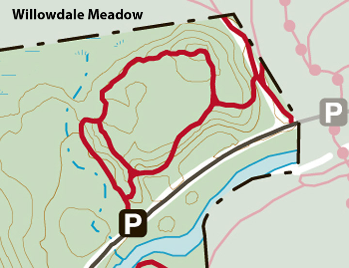
Willowdale – 40 acres – Map 50, Lot 2: This partnership acquisition was completed in June 2001. Essex County Greenbelt Association was a key partner in this project which also included the Department of Environmental Management (DEM) and the Town of Topsfield. This 40‐acre inholding within Willowdale State Forest was slated for development before the project partners stepped in and successfully negotiated the acquisition. The project partners contributed the following amounts to the acquisition: Department of Environmental Management ($1,400,000), Essex County Greenbelt Association ($700,000), Town of Ipswich ($300,000), and the Town of Topsfield ($100,000), for a total of $2,500,000. DEM holds an 84% interest in this property, the Town of Ipswich holds a 12% interest and the Town of Topsfield a 4% interest, reflecting the financial contributions of the various partners. Because the parcel is part of the Willowdale State Forest complex, the partners have agreed that the property will be managed by DEM. This project was the first expenditure out of the Open Space Bond.
Ross Property
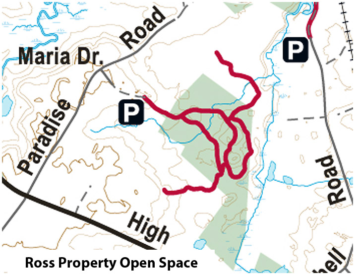
Ross – 29.5 acres – Map 21, Lot 104: In September 2001, the Town received a “Notice of Intent to Sell” under Chapter 61A for the Ross property off of Maria Drive. Since this parcel may provide a site for the relocation of “Brown’s Well” off of Route 1A and therefore has significant public benefit in addition to the wildlife habitat and potential public trail network that it provides, the Open Space Committee and Department of Planning and Development recommended and the Board of Selectmen agreed, that the Town should act on its right of first refusal under Chapter 61A. This parcel was added to the “list of priority parcels” for which Open Space Bond funds can be expended per the vote of the fall 2001 Special Town Meeting. The Town purchased the property on April 30, 2002. The Town also received a grant from the Department of Environmental Protection to cover 80% of the acquisition price. After this reimbursement, the Town’s cost for this property was $78,000.

Scott Farm Conservation Restriction, Mill Road: 83.5 Acres – Map 53C, Lot 12
In the spring of 2001, the Town was approached by Ipswich River Preservation, LLC (IRP), which had recently formed in order to acquire and protect Scott Farm. This conservation restriction eliminates all development from 45 acres including all of the front fields, all of the river frontage, and adjacent forest. The Town paid a total of $1.45 million out of the Open Space Bond authorization (spring 2000 ATM) for the purchase of this conservation restriction. This was the second expenditure using funds from the Town’s Open Space Bond.
Other Conservation Land in Ipswich
Boone Park (Town park)
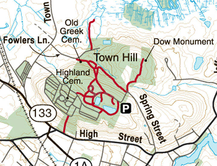
Daniel Boone Park is at the top of Spring St. in Ipswich MA. Turn left at the park entrance and park at the designated parking area. In 1957 the park was established by Ipswich Rotarians as a testimonial to the Rev. Daniel Boone, rector of a local church and tireless worker for the residents of Ipswich. The park predates the Open Space Program and is under the supervision of the Parks and Cemetery Department. A short trail across from the gated entrance takes you to a plaque on a bolder honoring artist Arthur Wesley Dow, who gave fifteen acres to the Town. The boulder reads: “I give to the Town of Ipswich Bayberry Hill (so called by me) within the said town with a commanding view which is dear to me over the marshes, creeks, river, and hill to the ocean to have and to hold by said town and its inhabitants forever for the use of the public as a place of recreation and enjoyment.”
New England Biolabs trails (Ipswich Great Estates)

The former James H. Proctor Estate lies between County Rd and Fellows Rd., built by James H. Proctor in 1895. The Catholic Church purchased the property, where it was used as a novitiate by the Oblates of Mary Immaculate, and later became the Catholic school Don Bosco. Since 1999 the Proctor estate has been the home of New England Biolabs, which provides walking trails open to the public, in connection with the Ipswich Great Estates Bylaw.
Downtown Ipswich Riverwalks (3)
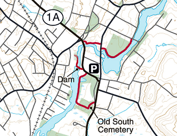
Trails, paths and walkways lead through the historic center of Ipswich. A parking lot for the Riverwalk behind Market Street was provided by EBSCO, and the town and state provided a new pedestrian bridge, replacing one that had been destroyed years earlier. Cross South Main to the Visitor Center/ Veterans Memorial Green. A short distance further a narrow trail winds along the River, ending at the Old South Cemetery. From the County Street Bridge, follow the Sidney Shurcliff Riverwalk to the Town Hall, and continue along Scenic Water Street to the Town Wharf. These trails predate the Ipswich Open Space Program.
Willowdale State Forest (State-owned)
Willowdale offers trail-use opportunities on 40 miles of trails and fishing and boating on 100-acre Hood Pond, owned and managed by the Commonwealth of Massachusetts. There are no developed recreational facilities at the Forest which exists as two separate parcels divided by Route 1. The eastern block of the Forest abuts Bradley Palmer State Park and the Ipswich River.


Sandy Point State Reservation (Massachusetts State Parks)

Sandy Point is a 777-acre park at the very southern tip of Plum Island and is an important nesting area for the piping plover, a threatened species, and the least tern, a species of special concern in Massachusetts. Passive recreational activities include walking, beachcombing, fishing, and birding. Access is through the abutting Parker River National Wildlife Refuge.
Crane Estate (Trustees of Reservations)

The spectacular Crane Estate encompasses more than 2,100 acres in Ipswich and includes three properties: Castle Hill, a National Historic Landmark that is the home of The Great House, Crane Beach, and the Crane Wildlife Refuge, with miles of trails through the dunes and along the Castle Neck River.
Appleton Farms (Trustees of Reservations)

Appleton Farms is the nation’s oldest operating farm, with 658 acres of wide open fields and active agriculture, including livestock, hay, and produce. Meandering farm roads and working farm yards are surrounded by ancient trees and beautiful views. Adjoining to Appleton Farms Grass Rides.
Hamlin Reservation (Trustees of Reservations

This former coastal farmland now welcomes visitors to a broad salt marsh and a dike path that leads to a one-mile loop trail around Eagle Island. The island overlooks the extensive open marsh and is one of the least disturbed parts of the entire 25,000-acre Great Marsh.
Julia Bird Reservation (Essex County Greenbelt)

The 59-acre Julia Bird Reservation parallels the railroad tracks and extends out to the banks of the Ipswich River. Adjacent to Appleton Farm, it is part of an extensive network of protected open space along the Ipswich River throughout Ipswich, Hamilton, Wenham, and Topsfield. In recent years, this connected “greenbelt” has been the site of the New England Sled Dog Race Series in January.
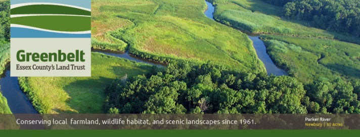
Essex County Greenbelt
Greenbelt’s 5400 acres of conserved landscapes across Essex County, including 29 properties in Ipswich. All properties owned by Greenbelt are open to the public free of charge.
Bay Circuit Trail

The Bay Circuit Trail is a permanent recreation trail and greenway extending through 37 towns in Eastern Massachusetts, linking parks and open spaces in fifty-seven Boston area communities. Since its founding in 1990, the Bay Circuit Alliance (BCA) has served as the catalyst to make the Bay Circuit dream come true. More than 230 miles of multi-use, passive recreational trail have now been dedicated, thanks to the contributions of hundreds of volunteers in 37 cooperating towns. The Alliance is a partnership of organizations and individuals, public and private, working to complete the Bay Circuit Trail and Greenway. BCA’s membership consists of six regional, four statewide, and more than 30 local member organizations, plus many interested individuals. Beginning at Plum Island and ending in Kingston Bay, the trail and greenway, is located close to 4 million people in Eastern Massachusetts. The trail provides close-to-home recreation including walking, biking, snowshoeing, horseback riding, and cross-country skiing.
Trails in Ipswich and the surrounding area
Ipswich
Appleton Farms, County Rd. Ipswich. Trails from the Visitor Center connect with Appleton Farms Grass Rides in Hamilton. Appleton Farms trail map
Bay Circuit Trail, Boxford, Ipswich, Rowley, Newbury, Newburyport. Trail map for the Ipswich-Rowley section of the Bay Circuit Trail
Bradley Palmer State Park, Topsfield Rd., Ipswich Winthrop Rd. Hamilton, Asbury St., Topsfield. Download Willowdale and Bradley Palmer trail map. Download the Trail map for Bradley Palmer SP.
Crane Beach and Castle Neck, Argilla Rd. Ipswich. Over 6 miles of trails through the dunes and around the Castle, plus several miles of beach to walk on. Castle Hill area trail map
Daniel Boone Park, Top of Spring Street on Town Hill in Ipswich.
Dow Brook Conservation Area, Dow/Bull Brook Reservoirs, High St., Ipswich. A three-mile hike begins at the Veterans recreational field on Mile Lane near Linebrook Road in Ipswich or near White Farms Ice Cream on High St.
Hamlin Reservation, Argilla Rd., Ipswich A mile-long trail takes you to a wooded coastal island.
Hood Pond, Linebrook Rd., Ipswich. 100-acre pond crossed by the Bay Circuit Trail, Massachusetts Department of Conservation & Recreation.
Julia Bird Reservation, Waldingfield Rd., Ipswich adjacent to Appleton Farm, it is part of an extensive network of protected open space along the Ipswich River.
Linebrook Woods Conservation Area, 275 Linebrook Rds., Ipswich next to Marini Farms. A 78-acre parcel of wooded uplands and wetlands, with trails extending north to the town watershed lands trail network, and to the south into Willowdale State Forest.
New England Biolabs trails, Public trails in the former Proctor Estate along the Miles River.
Nichols Field, 60 Labor in Vain Rd., Ipswich. A 15-acre parcel of open fields and woods adjacent to the Ipswich River.
Riverbend, Ipswich River Watershed Association. Trail loop from the headquarters down to the Ipswich River.
Ross Property, Open Space program property off of Paradise Rd., Ipswich.
Sally Weatherall Saltmarsh & Viewing Platform
Sandy Point State Reservation, Plum Island (accessible by Newburyport). Located at the southern tip of Plum Island, Sandy Point stretches 77 acres. It features a beautiful coastal beach great for swimming and sunbathing.
Shady Creek Conservation Area, Colonial Acres, Topsfield Rd. Located at the end of the cul-de-sac on Colonial Drive, a 44-acre parcel of wooded uplands and wetlands along the Ipswich River. This area has limited trail access and no river access.
Sidney Shurcliff River Walk, Ipswich. A pleasant short walk along the Ipswich River from the County St. bridge to Town Hall at Water St.
Steep Hill and Cedar Point, Crane Estate, Argilla Rd.
Strawberry Hill, Jeffreys Neck Rd., Ipswich. Located at 56 Jeffreys Neck Road, a 91-acre parcel of open fields and marsh adjacent to the Eagle Hill River. Across Jeffreys Neck Road from The Trustees of Reservations Greenwood Farms property is also open to the public.
Willowdale Meadow. Topsfield Rd., Ipswich. One of several starting points for walks through Willowdale State Forest East. The property is an old meadow with some single track
Willowdale State Forest, 40 miles of trails. The East side on Topsfield and Linebrook Rd. connects to Hood Pond, Willowdale West.
Harold Parker State Forest. Miles of trails and mountain biking between Middleton and Andover.
Andover
Ward Reservation, Prospect Road Andover, and North Andover. Almost 10 miles of trails, easy-to-moderate hiking, strenuous in places. Some of the trails here are part of the Bay Circuit Trail.
Weir Hill, Stevens Street, North Andover. Four miles of trails with vistas of both scenic Lake Cochichewick and of the broader landscape of the Merrimack Valley.
Essex
Cox Reservation, 82 Eastern Avenue, Essex. Stunning views of a breathtaking tidal estuary in the Great Marsh ecosystem.
Stavros Reservation, Island Rd., Essex. This reservation protects more than 50 acres of salt marsh. A loop trail leads you along a field and up the hillside to a broad, open meadow. Here stands the fieldstone base of a 50-foot, three-level tower.
Gloucester
Ravenswood Park, 481 Western Avenue (Route 127)Gloucester. 10 miles of trails and former carriage roads. Moderate hiking. Carriage roads are covered with dense crushed stone and are generally wheelchair accessible.
Halibut Point Reservation. 2.5 miles of trails with weather-beaten bluffs, ocean views and low rocky coastal shelf.
Dogtown Commons, Cherry St., Gloucester MA. Five square miles of abandoned settlement in a glacial rock field.
Hamilton
Appleton Farms Grass Rides, Highland Ave., Hamilton. Miles of carriage trails abutting Appleton Farms and Harvard Forest.
Discover Hamilton Trail, which includes part of the Bay Circuit Trail, runs from Bradley Palmer State Park through the Pingrey Estate, Appleton Farms, and Harvard Forest.
Harvard Forest, Cutler Rd. The Harvard Forest recreation ground is owned by the Harvard University. It is 116 acres. This property is open to the public. The property has 1.7 miles of public trails.
Pingree Reservation, Cutler Rd. This 136-acre property has wide paths interconnected by single track and is a part of the Bay Circuit Trail and the Discover Hamilton Trail, connecting to Harvard Woods
Donovan – Sagamore Trail, Sagamore St., Hamilton. The Donovan/Sagamore Hill Trail connects the Donovan fields area with Sagamore Street via the Donovan Woods and Donovan Hill. The southern half of the trail is located on public lands owned by the Town of Hamilton. The northern half of the trail is a public trail easement that crosses through private properties. The single-track trail is mostly wooded and the terrain is relatively steep on either side of the hill.
Manchester by the Sea
Agassiz Rock. School Street, Manchester. A Trustees of Reservations property. Moderate climb to some unusual boulders overlooking Cape Ann. 1.5-mile loop trail (moderate hiking) takes in both Big and Little Agassiz Rocks.
Coolidge Reservation, Rt. 127, Manchester-by-the-Sea. A one-mile trail runs from the parking area to the top of Bungalow Hill, around Clarke Pond to Magnolia Beach, and to the Ocean Lawn.
Newbury, Newburyport and West Newbury
Brake Hill and Groveland Town Forest, Rt. Rt. 113, West Newbury. The highest point in West Newbury (Elev. 258′). Parking is available along the street near 19 Hill Top Circle or on Brake Hill Terrace near Route 113.
Chestnut Hill Farm, Farm Rd., West Newbury. Loop trail through farmland to the Merrimack River, easy walking on grass pathways with river views from the overlook. The parking lot is located at the end of Farm Lane.
Crane Pond Wildlife Management Area, Bear Hill Road Groveland. Multiple parking areas in Groveland (Little Road, Bear Hill Rd) Newbury (Moody St), and Georgetown (Little Rd). In West Newbury, parking is available at the end of Georgetown Road near the Groveland town line.
Indian Hill Reservoir, West Newbury. Level roadway and trail around the reservoir. Connects to Indian Hill Farm.
Little River Nature Trail, High St. Newburyport. A rich wildlife habitat, 5-mile trail surrounded by an urban setting. Easy terrain including meadows, forests, vernal pools, and wetlands.
Martin Burns Wildlife Management Area, Orchard St., Newbury MA.
Maudslay State Park, 74 Curzon Mill Road, Newburyport. Former estate with over 400 acres of parkland owned by the state along the Merrimack River.
Old Town Hill, Newman Rd., Newbury. A three-mile network of trails and pathways leads you along the Parker River and a ridge with scenic views.
Parker River National Wildlife Refuge Hell Cat Trail, Plum Island. This boardwalk trail is divided into the 0.6-mile Dunes Trail and the 0.8-mile Marsh Trail.
Riverbend Conservation Area, adjoining Maudslay SP, Newburyport. Riverbend Conservation Area trail map
Rowley
Hunsley Hills, Rt. 133, Rowley. A 1-mile loop trail that offers the chance to see wildlife and is good for hiking, walking, and nature trips.
Prospect Hill Conservation Area, Rt. 133, Rowley. Part of the Bay Circuit Trail, it connects to Dow and Bull Brook Conservation, Linebrook Conservation, and Willowdale State Forest.
Topsfield
Bare Hill Park, Rt. 97, Topsfield.
Ipswich River Wildlife Sanctuary, 87 Perkins Row, Topsfield. 12 miles of trails invite you to explore the forests, meadows, wetlands, drumlins, and eskers. You can also travel down the namesake river,
Topsfield Linear Common. Start: Downtown Topsfield, approximately 4 miles long, connecting to sections of the Border to Boston trail in Wenham, Danvers, and Beverly, and north to the Boxford town line.
Topsfield Town Forest, Rt. 97 at Hood Pond.
Grand Wenham Canal, connect with a side trail on the Topsfield Linear Common and Ipswich River.
Wenham
Cedar Pond, Rt. 97, Wenham. The wildlife sanctuary contains approximately 110 acres of upland forest.
Chebacco Woods, 255 Grapevine Rd, Wenham. The Gordon College trails vary from easy flat dirt roads to singletracks.
J.C. Phillips Nature Preserve 85 acres. The Phillips family continued to live on the property with his sons purchasing adjoining properties and expanding Moraine Farm. The Nature Preserve is now jointly managed by the Trustees of Reservations and the Essex County Greenbelt. J. C.
Posts
 240 County Road, the Proctor Estate, New England Biolabs (1895) - The former James H. Proctor estate was built in 1895. The Catholic Church purchased the property, where it was used as a novitiate by the Oblates of Mary Immaculate, and later became the Catholic school Don Bosco. Since 1999 the Proctor estate has been the home of New England Biolabs, which provides walking trails open to the public.… Continue reading 240 County Road, the Proctor Estate, New England Biolabs (1895)
 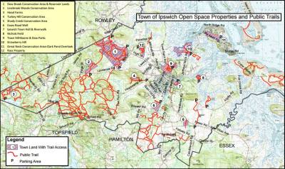 Open Spaces - Town meetings in Ipswich have voted to protect hundreds of acres of land, through the Open Space Program, making it available for the general public and preserving the land from development. … Continue reading Open Spaces
 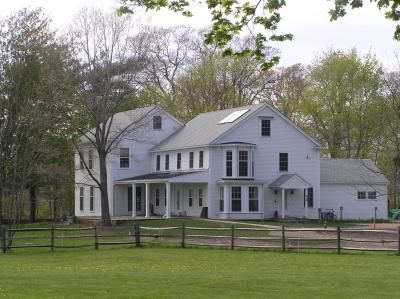 Appleton Farms - Owned by the Trustees of Reservations, Appleton Farms is America’s oldest working farm, with 12 miles of walking trails, a visitor center, and Community Supported Agriculture program.… Continue reading Appleton Farms
 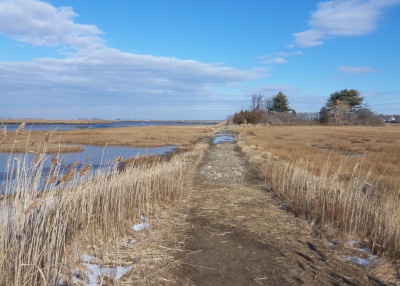 Strawberry Hill and Greenwood Farm - The landscape surrounding Strawberry Hill on Jeffreys Neck Rd. invokes a time when saltwater farms were common in Ipswich. Across the street is Greenwood Farm and the First Period Payne House, owned by the Trustees of Reservations. … Continue reading Strawberry Hill and Greenwood Farm
 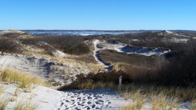 Winter Walks in the Dunes at Castle Neck - Crane Beach and all of Castle Neck are protected by the Trustees of Reservations. Pitch pine and scrub oak rise from the masses of marsh grass, sage green hudsonia and dune lichen lining the trails that wind through the dunes.… Continue reading Winter Walks in the Dunes at Castle Neck
  Destination Topsfield: Mass Audubon’s Ipswich River Wildlife Sanctuary - Massachusetts Audubon's Ipswich River Wildlife Sanctuary at 87 Perkins Row in Topsfield has miles of trails weave through an amazing mix of forests, meadows, and wetlands, with beautiful views of the Ipswich River from an observatory and two glacial eskers. … Continue reading Destination Topsfield: Mass Audubon’s Ipswich River Wildlife Sanctuary
  Destination Ipswich: The Castle Neck River Reservation - In 2019, Essex County Greenbelt worked with the Town of Ipswich and the Massachusetts Department of Fish and Game to create the Castle Neck River Reservation, the Pony Express soccer fields, and the Castle Neck River Wildlife Management Area. … Continue reading Destination Ipswich: The Castle Neck River Reservation
  Choate Island and Rufus Choate - Choate Island was originally known as Hog Island, and is the largest island in the Crane Wildlife Refuge and is the site of the Choate family homestead, the Proctor Barn, the White Cottage, and the final resting place of Mr. and Mrs. Cornelius Crane. There are great views from the island summit of the Castle Neck dunes and Plum Island Mount Agamenticus in Maine.… Continue reading Choate Island and Rufus Choate
  Destination Ipswich: Turkey Hill & Kamon Farm - In this episode, we took a 3 mile walk that started at the Turkey Hill Conservation area trailhead on Pineswamp Rd., and followed a connector trail to Essex County Greenbelt's new property, Kamon Farm. From there we enjoyed a scenic return on Pineswamp Rd. to the small parking lot for Turkey Hill.… Continue reading Destination Ipswich: Turkey Hill & Kamon Farm
  Dow Brook and Bull Brook - Bull Brook originates in Willowdale, crosses Linebrook Rd. and merges with Dow Brook at the Ipswich Utilities site on Rt. 1A. From that point the combined stream becomes the Egypt River.… Continue reading Dow Brook and Bull Brook
 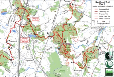 The Bay Circuit Trail in Ipswich - The Bay Circuit Trail in Ipswich enters Willowdale State Forest and continues north through the town-owned Dow-Bull Brook preservation land. A branch continues from Willowdale through Bradley Palmer S.P to New England Biolabs.… Continue reading The Bay Circuit Trail in Ipswich
 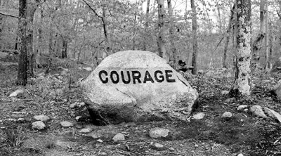 Dogtown, its History and Legends - Dogtown is a five square mile area of Gloucester and Rockport strewn with glacial boulders. Visitors to Dogtown find cellar holes of abandoned houses, and boulders emblazoned with inspirational messages. … Continue reading Dogtown, its History and Legends
  The Farm at Wigwam Hill - Symonds Epes bought a large tract in 1726 and built a substantial farm and orchards at Wigwam Hill, named for a group of destitute Indians who briefly camped there. The protecting pitch pines were later cut for lumber, and the farm became a large dune.… Continue reading The Farm at Wigwam Hill
Great post. Everyone would love Ipswich to remain as rural and undeveloped as possible, but the fears that it will be nothing but parking lots, houses and businesses in 10 years are simply unfounded.
Was Maplecroft Farms ever in it’s long history, in possession of a Burnham family? I was told around the turn of the 19th-20th century that it was; but my great or great-great-grandfather lost the property. Just curious.
Yes, the original owner William G. Horton. married Caroline Burnham, daughter of Foster and Helen Burnham. https://historicipswich.org/94-essex-road/